Appledore Harbour
Appledore Harbour
If Appledore was once a port, where was the harbour? ‘Harbour’ may not be the right word, of course, and it may make more sense to think of a landing-jetty, or a landing-place where boats were pulled onto the shore.
Reproduced below is an article from ‘The Romney Marsh Irregular’ (March 2004), the newsletter of the Romney Marsh Research Trust. The Trust was wound down in 2012, although much of the research remains available to the public on their website: http://rmrt.org.uk/
Naturally, we make full acknowledgement of the Trust’s work, which in this case included a notable contribution by Liz Owen of the Appledore Local History Society.
The Tithe Map and the Search for a Small Port at Appledore
The river system associated with Romney Marsh provided medieval society with a ready-made transport network, linking the main seaports, via intermediate staging posts, to inland end points. One such staging post, on a branch of the Rother, may well have been the town of Appledore.
Pre-c.1250 the main channel of the Rother flowed south of the Isle of Oxney, with Appledore on a tidal branch to the north. This was a period of economic and population growth, with benign climatic conditions. The 12th century was a time of extensive land reclamation.
The Appledore jetty, for which we have documentary evidence, would perhaps have been used mainly for local Appledore river trade to and from the port of Romney, but it could also have been used by sea-going coastal vessels.
After c.1250, with the sea breaching the shingle bank at Winchelsea and inundating the land, and then, from c.1330, with the diversion of the Rother, by the Knelle Dam, round the north of the Isle of Oxney, the significance, and even the location, of the Appledore landing jetties could well have changed. Appledore was granted its official market by Edward III 1359, at about the same time as Horne Place was established, with its chapel being licensed in 1366.
This article reports an investigation of the Appledore Tithe Map, which is part of a much larger project, involving documentary evidence and extensive field walking. The research did not cover any detached portions of the Appledore parish.
The Appledore Tithe Map
The Appledore Tithe Map of 1840 provides an accurate map of the fields within the parish boundary, together with a statement of their then ownership. The Tithe Commutation Act of 1836 had converted historic tithes in kind into a more modern annual money rent on a fairly uniform national basis. An essential element of this process was the careful mapping and recording of all lands within a parish.
Tithe Maps, for Kent, are now accessible by CD ROMs, which are good for studying small areas, but present problems for working at the level of the whole parish and at a scale appropriate for data analysis.
The Apportionment Rolls, which are held in the Canterbury Cathedral archive, contain field details, areas, names, ownership and use (arable, pasture, etc.), together with a number for each field, which also appears on the map.
The research method was to collect the data from the Apportionment Roll and transfer it to a suitably large-scale version of the Tithe Map. Two researchers were needed for the data collection – one to handle the rolls and dictate the field data to the second, who then entered them onto a spreadsheet for subsequent analysis.
The main difficulty was matching the field numbers on the roll to those on the map. Apart from problems of legibility, the logic of the field numbering was sometimes difficult to unravel, as they mainly followed patterns of ownership.
Descriptive field names were recorded and mapped in the hope that they might indicate earlier, possibly medieval, usages. However most fields are simply named by size – ‘five acre field’, ‘ten acre field’ etc. – so providing few clues, although two adjacent ‘Ferry Fields’ might indicate the departure point for the Oxney ferry and perhaps even give a clue to the width of the then Rother at that point.
The lands owned in 1840 by the Dean and Chapter of Canterbury Cathedral were readily identified from the rolls and can largely be equated with those of the medieval Priory, which had an important manor at Appledore. This identification would help in locating features mentioned in the many surviving documents of the manor.
The larger fields were also identified to see if any patterns emerged, the hypothesis being that the larger fields might be later enclosures and innings, or that certain landowners held disproportionately more of the larger fields. Field size remains a promising area for further research.
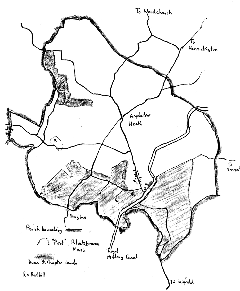
The Tithe Map also clearly established the parish boundary as extant at 1840, which is probably a good indicator of medieval boundaries, although complicated by subsequent innings, the seventeenth-century re-diversion of the Rother south of the Isle of Oxney and finally by arrival of the Royal Military Canal, 1804-9.
The five-metre contour line, which stands as a proxy for the limit of various inundations and natural flood levels, was used to relate the 1840 field boundaries to the historic shoreline.
Blackbourne Marsh
Gill Draper has found clear evidence in the Canterbury Cathedral Archives (see ‘Appledore: a small medieval port’ Irregular No 21, March 2003) of the Priory, in the mid 12th century, leasing, for reclamation, a marsh of 52 acres to the men of Blackbourne, who occupied a den, of more than seven acres on the upland fringes of the Marsh.
The southern boundary of the marsh was a tidal estuary of the Rother. By the mid-13th century, the records indicated there was a hythe on the Rother with a jetty immediately to the south-east of Blackbourne marsh. The jetty could of course have pre-dated the reclamation, perhaps from the eight-century, when produce from Appledore was apparently taken to Adisham, five miles south-east of Canterbury. The journey would have been 25 miles overland, or 50 miles by water round the coast and up the River Stour.
If we could locate Blackbourne marsh, this would provide a firm date for any surviving features associated with the reclamation and would greatly narrow the search for the Appledore jetties.
The Blackbourne marsh, according to the documentary evidence, lay just to the west of Appledore. The Appledore-Oxney road, which crossed the Rother on a bridge, was adjacent to the marsh. This may be the bridge mentioned in the charters, which later became a ferry, although the charters could be referring to a bridge over a sluice, across a small stream, running beside and draining the reclaimed marsh, perhaps the eponymous “Black Bourne”.
Findings
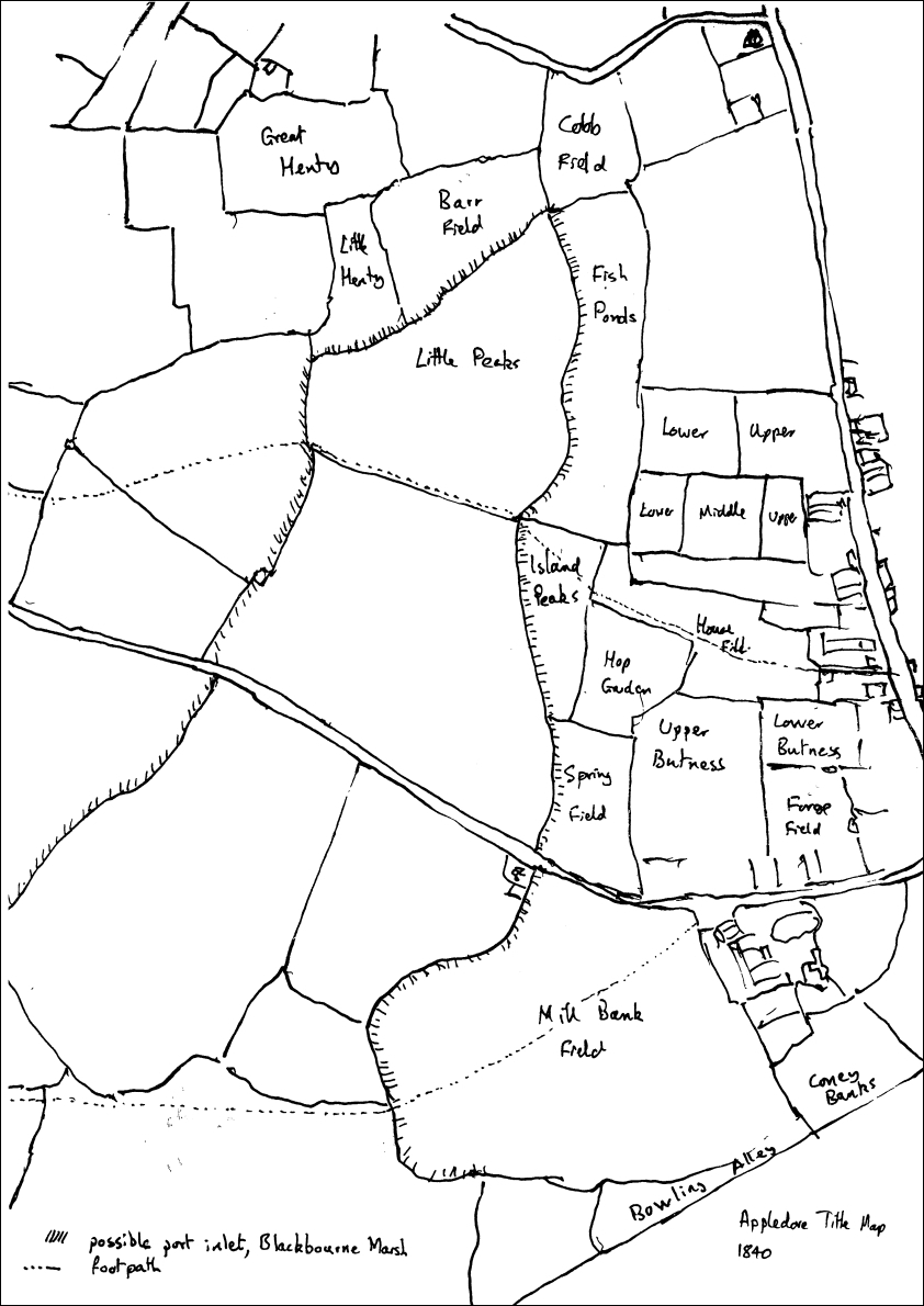
From the Tithe Map, there is a promising fifty or so acre site for Blackbourne marsh on the western side of the Appledore peninsular, consisting of five fields, in an inlet shaped area. The head of the “inlet”, which is oriented north-south, is at TQ955298, just south of the B2080 from Appledore to Tenterden.
The inlet is crossed at its southern end by the road running from Appledore to Stone-in-Oxney, which could mark the limit of the main 12th century reclamation and provide an important clue to the location of the jetty.
The 1840 field boundaries coincided with an inlet indicated by the geological map of the district (Geological Survey of Great Britain (England and Wales) (1981) Tenterden Sheet 304 Ordnance Survey). The inlet area consisted of marine alluvium, mostly sand. The immediate narrow edges of the inlet were ‘Clay in Tunbridge Wells Sand’, with the hill itself made of ‘Tunbridge Wells Sand’. Appledore Heath itself consists of ‘Weald Clay’.
The sandy marine alluvium of the inlet extends up river to near Newenden and across most of Shirley Moor. Down river it is replaced, roughly along the line of the Highknock Channel south from Priory Farm (TQ960276), by a mostly clay marine alluvium. The Highknock Channel is probably a one-time line of the course of the old Rother.
The former inlet, which might once, before it silted up and formed a salt marsh, have been a Saxon haven or “port”, can also be traced on the ground, with a flat area bounded on one side by the slope up to Appledore and on the other by slightly undulating land, which continues across to Redhill (TQ940302), which is a distinct landscape feature, breaching the five metre line. It is of course quite possible that the reclaimed land was re-flooded during the late 13th century inundations, so complicating the search for the small port of Appledore.
The geology map suggests that in this area the five-metre line is an inconsistent indicator of flooding limits, as parts of the low lying land around Redhill are remnants of the Tunbridge Wells Sands high ground.
Field names and patterns
The Tithe Map has names for the fields running beside the putative reclaimed marsh – from the northern or head end: Cobb Field, Fish Ponds, Island Peaks, Spring Field and Mill Bank Field. The first three fields lie within the five-metre line, and may well have been part of the reclamation, while the contour line passes through Spring Field and skirts round the edge of Mill Bank Field.
Barr Field and Little Henty Field lie across the northern edge of the inlet, again between it and the five-metre line.
Of the two large fields, which would have made up the main reclamation of the former inlet, only the head or northern field has a name – Little Peaks. There is a stream or watercourse separating the two large fields from the three smaller side fields.
All these fields, except Cobb, Barr and Little Henty are part of the Dean and Chapter’s estate, which suggests that those three were already land prior to the inning of the harbour creek. Little Henty is adjacent to and south of a field called Great Henty. These are all small irregular shaped fields and provide a possible location for the den, which was home to the men of Blackbourne, responsible for the reclamation.
Innings walls
The Tithe Map shows a footpath, which is still there, from Appledore alongside the boundary between Fish Ponds and Island Peaks fields. This footpath continues along field boundaries towards Redhill, where a Church Field (TQ939302) occupies its north-western section, but see below.
It is a reasonable hypothesis, based on Tithe Map boundaries, that this path initially runs along the top of a wall used as the first stage of inning the former creek. Similarly the road from Mill Bank towards Stone could mark the second stage of the Blackbourne marsh inning process. The road from Appledore to Oxney would have crossed a bridge over the stream, perhaps with a sluice, by the Mill Bank Field.
The final reclamation stage appears more complex. The probable site of the “port” was narrowed by a large inned field on the western side, leaving a residual creek immediately alongside Mill Bank. This final creek appears to have been inned in one or two relatively small stages, presumably leading to the closure of the port at this specific location. These outer field boundaries might represent a much earlier, pre-innings, course of the “Black Bourne”.
Dean and Chapter’s Lands
The Dean and Chapter’s estate runs uninterrupted in a horseshoe south of the Appledore peninsular from the Rhee Wall to the Redhill estate, with a further smaller Priory estate beyond Redhill. Nineteen fields separate the two Priory estates, all bar three in the ownership of Edward and James Taylor, who are major landowners in Appledore.
One of their fields is intriguingly known as ‘Church Field’. This may refer to a field, which once belonged to the Parish Church for the support of its priest, or perhaps to an actual church, chapel, chantry or wayside shrine, built on the slightly higher and drier ground at Redhill.
There is a curious reference to this in Hasted (1798) History of Kent, VII, to the present Appledore Church being on the site of Appledore Castle, with the parish church (inconveniently) located a mile or so outside the town at Church Field, Redhill.
The Archbishop of Canterbury directly owned 24 acres of land, which lie on either side of the main street of Appledore. The fields run from Fish Ponds Field, across the Appledore spur, and down to the five-metre line on the eastern side, where there is perhaps a plausible channel up to Horne Place, but no real evidence from the tithe or geological maps.
The larger fields are predominantly found in the reclaimed marsh area from the Rhee round to Shirley Moor. Many of these fields were Dean and Chapter lands. In the Appledore Heath area there are also some larger fields, presumably as a result of enclosures. These are not Dean and Chapter lands.
Conclusion
Although no conclusive evidence emerged, research based on the Appledore Tithe Map indicated a probable site, on the western side of the town, for Blackbourne Marsh, which was reclaimed in the late 12th century. This would fix the site of the Appledore jetty, at around that date, almost certainly somewhere along the western or just possibly southern edge of Mill Bank Field.
Tithe Map analysis offers a useful additional tool for reconstructing lost landscapes. Further systematic work on the Tithe Maps for Stone, Ebony and for parts of Tenterden, Rolvenden and Newenden have the potential to shed light on possible river-based medieval transport networks and patterns of medieval land ownership.
More work is also needed to see whether the early jetty, associated with Blackbourne marsh, continued into the 14th and 15th centuries as Appledore’s small port. There is also the question as to whether Blackbourne Marsh had once been an inlet providing a haven and moorings for Saxon ships. Could this also have been the landing place for the Danish war-party which sacked Appledore in 892, or did the attack come from a different direction altogether?
The Appledore Tithe Map research was mainly carried out by Terry Burke and Sheila Maddock in the second half of 2003. The research would have been impossible without the work of Marion Gulliver and Liz Owen, who not only helped with the data capture in Canterbury, but also, through their own research and extensive field walking, had already identified the western slopes as a possible port location.
Stephen Draper made possible the visual analysis of the data by solving the problem of printing the information on the Tithe Map CD to a sufficient size. Thanks too are due to Alan Tyler for the Hasted reference to a possible church on Church Field.
This research, which is part of a larger project led by Helen Clarke and Gill Draper, is supported by a grant from the Romney Marsh Research Trust.
Terry Burke
Bibliography
- Apportionment roll, Appledore parish (1840), Canterbury Cathedral Archives
- Appledore Tithe Map (1840) CD ROM, ArcAngel, Kent County Council
- Evans, E.J. & Crosby, A.G. (1997) Tithes Maps, Apportionments and the 1836
- Act: a guide for local historians 3rd Edition, British Association for Local History Explorer 125 (1998) Romney Marsh Rye & Winchelsea Ordnance Survey
- Geological Survey of Great Britain (England and Wales) (1981) Tenterden
- Sheet 304 Ordnance Survey
- Kain, J.P. & Prince, H.C. (2000) Tithe Surveys for Historians Phillimore